Accéder au contenu principal

Irene & Monique went to the Mountain


That day, Irene & Monique went to the Mountain. It wasn’t an ordinary Mountain. It was a prominent hill located at the banks of 
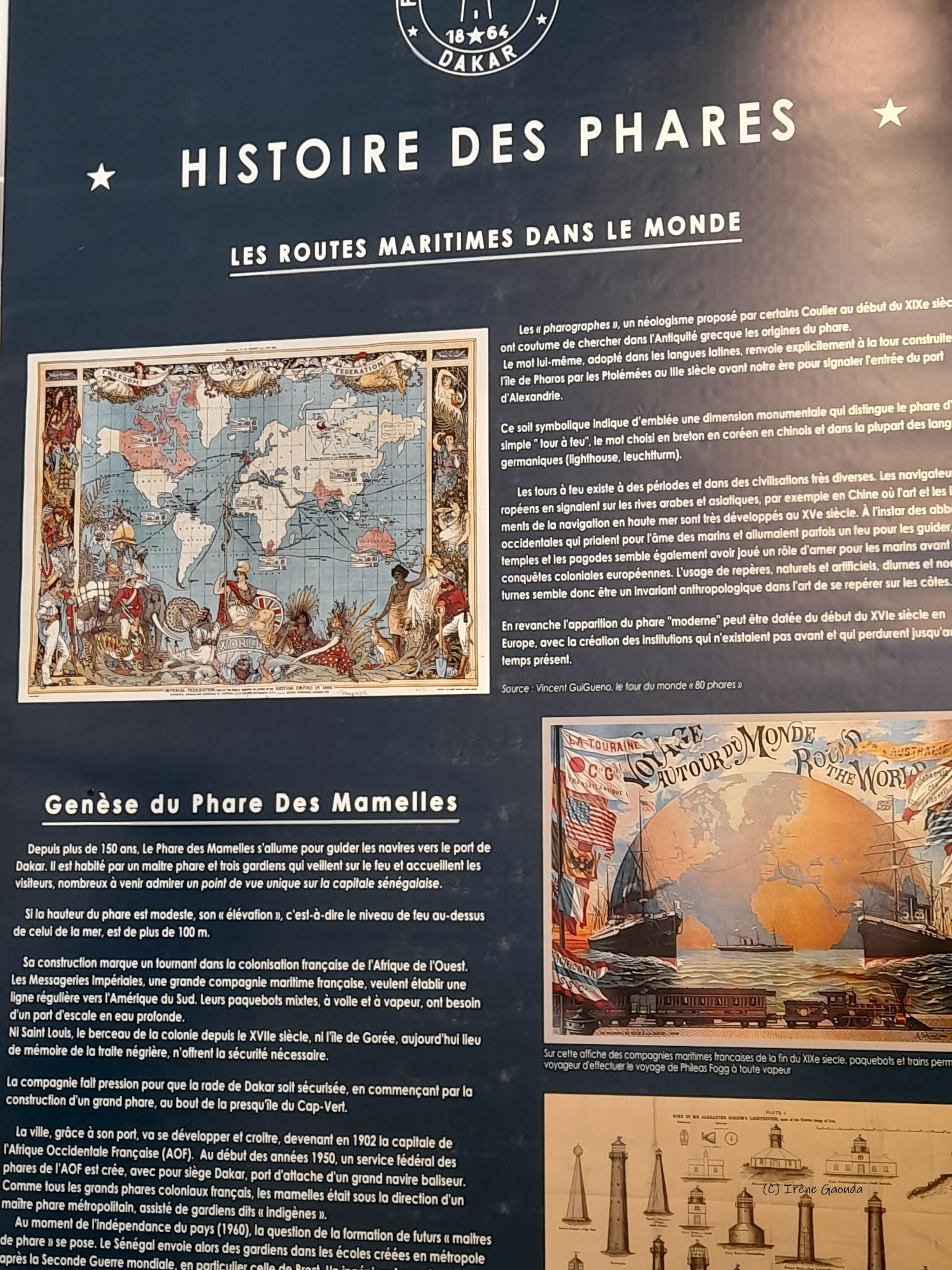
the Atlantic Ocean. On that hill was built more than a hundred years ago, a white lighthouse commonly called Phare des Mamelles...

Phare is the Lighthouse and Mamelles stands for a pair of prominent hills in Ouakam, a suburban district of Dakar, 9 km northwest of Senegal's capital on the Cabe verde peninsula. 

You can access the Lighthouse by car (transportation service available). You can also take a walk to the hill. 

For more than a hundred years, the Lighthouse has been lit to guide ships to the port of Dakar. 


It is inhabited by a master lighthouse and three keepers who watch over the location and welcome inquisitive visitors of a unique point of view over the Senegalese capital.
If the height of the lighthouse is modest, its elevation, that is to say the level of fire above that of the sea, is more than 100m.

Its construction marks a turning point in the French construction of West Africa.

Completed in 1864, it has been described as "one of the world's great lighthouses, guiding ships around the western tip of Africa.


On the second floor is the watch room, which is used by the duty keepers during the night.


A spiral staircase climbs up to the lantern room, containing the Barbier, Bernand and Turenne second order Fresnel lens that floats in a bath of mercury.


It is illuminated by a 1000 watt halogen lamp operating on alternating current at 220 volts. 


The light produces a white flash every five seconds at a focal height of 120 metres.


This is one of the world's great lighthouses, guiding ships around the western tip of Africa. Its light has a range listed at 57 km (almost 36 mi).

Views from the lantern gallery provide panoramic views of the entire peninsula, including Almadies, N’Gor, Ouakam, and the African Renaissance Monument which is located on the second the Deux Mamelles hills.

In addition to the lighthouse, you can also find shelter and restaurant services.


If you happen to fly to Senegal one day...

....give yourself a chance to discover the insights of the Lighthouse.


See you.....😜😜


Commentaires

Posts les plus consultés de ce blog

A la découverte de la commune de Guémé dans le Mayo-Danay

Située dans la Région de l’Extrême-Nord Cameroun, précisément dans le département du Mayo-Danay, la commune de Guémé occupe tout l’arrondissement de Vélé qui couvre une superficie de 400 km² et compte 18 villages. Voyage au coeur de la commune... Fruits d'oseille La Commune de Guémé a été créée par décret présidentiel N°93/321 du 25 novembre 1993. Elle est située dans la Région de l’Extrême-Nord Cameroun, dans le département du Mayo Danay, entre les 10e et 11e degrés de latitude Nord et les 14e et 15e degrés de longitude Est, pratiquement à la frontière du Cameroun avec le Tchad. Cette Commune qui occupe tout l’arrondissement de Vélé couvre une superficie de 400 km² et compte 18 villages répartis sur trois axes. La Commune de Guémé est limitée :  - Au Sud par la Commune de Yagoua ;  - Au Nord par la Commune de Kaïkaï ;  - A l’Ouest par la Commune de Kalfou et Moulvoudaye ;  - Et à l’Est par le fleuve Logone qui constitue en même temps la limite natur...

BOOK REVIEW: Irene Gaouda’s « The Enticing Legend of the Massa Warriors »

By Douglas ACHINGALE  When I first set eyes on a copy of "The Enticing Legend of the Massa Warriors", I thought the author had employed the word “enticing” simply to pull a fast one on the reader. But I was mistaken. Once I started perusing the work, I noticed that the lines were so luscious as to warrant me to get the very last page before I could drop it.  The first thing that glues the reader to the book is not so much the alluring front cover page picture of a female warrior on horseback as the epilogue which is a quote from one of the works of Africa’s all-time best storyteller, Chinua Achebe . It reads: “ I believe in the complexity of human story, and that there’s no way you can telle that story in one way and say, “this is “. Always there will be someone who can tell it differently depending on where they are standing… this is the way the world’s stories should be told: from many different perspectives ”. Douglas Achingale, right, during the book lunch. ...

One afternoon with the Massa people

The Massa who are often called « Banana » live on the flood plains bordering the middle course of the Logone River about 155 miles south of N’Djamena. In the 70’s, there were about 75 000 Massa in Cameroon and about 50 000 in the Republic of Chad. More recent statistics released by The Joshua project give an estmate of about 488 000 accross the world. Joyful moments The Masa build their enclosures on land above the flood line and keep their cattle near their huts only during dry season. In rural areas, they live by farming, fishing and raising livestock. They have a balanced diet, which is rare in the center of the savanna. The principal agricultural product is quick-growing red sorghum, which is grown on level ground during the rainy season. Millet, sorghum requiring transplanting peanuts, rice, beans and peas are subsidiary products. Fishing is carried on all year round in the Logone and its tributaries. When the floods subside, the men organize fishing expeditions in th...